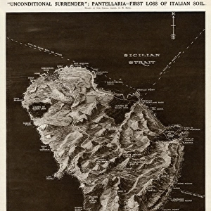
Allied occupation of French North Africa by G. H. Davis

![]()
Wall Art and Photo Gifts from Mary Evans Picture Library
Allied occupation of French North Africa by G. H. Davis
The Allied Anglo-American occupation of French North Africa during the Second World War. A contour map of the Algerian and Tunisian coasts, with distances from Algiers to important sites. Inset, a map showing the French Atlantic ports where Allied landings have occurred. Date: 1942
Mary Evans Picture Library makes available wonderful images created for people to enjoy over the centuries
Media ID 14133347
© Illustrated London News Ltd/Mary Evans
1942 Algeria Algerian Algiers Allied Allies Anglo Atlantic Coasts Contour Corsica Davis Distance Distances Important Landing Landings Maps Mediterranean Occupation Occupied Ports Portugal Route Routes Sardinia Sicily Sites Tunisia Tunisian
EDITORS COMMENTS
This print by G.H. Davis depicts the Allied occupation of French North Africa during the Second World War. The map focuses on the Algerian and Tunisian coasts, highlighting key distances from Algiers to significant sites. An inset map shows the French Atlantic ports where Allied landings took place, including Spain, Portugal, Sicily, Sardinia, Corsica, and Italy. The Allied forces, consisting primarily of British and American troops, invaded North Africa in 1942 with the aim of securing the Mediterranean Sea from Axis powers. The successful invasion marked a turning point in the war, as it prevented the Germans from advancing further into North Africa and allowed the Allies to establish a stronghold in the region. The map's contour lines provide a detailed representation of the terrain, making it an invaluable resource for military strategists and historians. The distances between important sites, such as Algiers and Tunis, are clearly marked, allowing for easy navigation and planning. The Atlantic ports shown on the inset map were crucial for the Allied forces, as they served as the primary staging grounds for the invasion. The map also highlights the strategic importance of the Mediterranean Sea, which was a major transportation route for supplies and troops during the war. This print is a fascinating glimpse into the history of the Second World War and the Allied occupation of French North Africa. It offers a unique perspective on the military strategies and logistics of the time, making it an essential addition to any history or military collection.
MADE IN THE USA
Safe Shipping with 30 Day Money Back Guarantee
FREE PERSONALISATION*
We are proud to offer a range of customisation features including Personalised Captions, Color Filters and Picture Zoom Tools
SECURE PAYMENTS
We happily accept a wide range of payment options so you can pay for the things you need in the way that is most convenient for you
* Options may vary by product and licensing agreement. Zoomed Pictures can be adjusted in the Cart.