Home > Science > Space Exploration > Planets > Earth
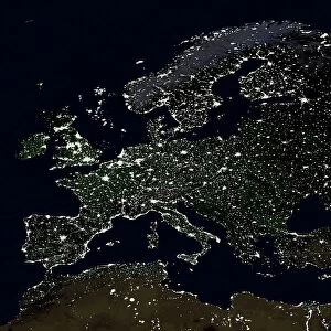
The Arctic, satellite image

![]()
Wall Art and Photo Gifts from Science Photo Library
The Arctic, satellite image
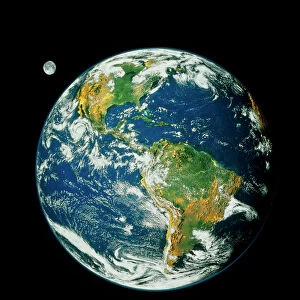
The Arctic. Satellite image of the Earth centred on the Arctic. The North Pole is at centre. Clouds and Arctic sea ice are white, oceans are blue and land is green and brown. Also seen are Asia (upper right), Europe (lower right), the Atlantic Ocean (bottom), North America (lower left) and the Pacific Ocean (upper left). This image was produced by combining data from the Defense Meteorological Satellite Program (DMSP), NOas POES and Nimbus 7 satellites and the MODIS instrument on board NASAs Terra satellite
Science Photo Library features Science and Medical images including photos and illustrations
Media ID 1705011
© PLANETARY VISIONS LTD/SCIENCE PHOTO LIBRARY
Arctic Atlantic Circle Circular Cloud Cloud Cover Clouds Cloudy Combined Data Continent Continents Day Time Defense Meteorological Dmsp Earth Observation Earth Science From Space Globe Land Land Cover Moderate Resolution Imaging Modis Nasa Nimbus 7 Noaa North Pole Northern Hemisphere Pacific Planetary Poes Polar Polar Orbiter Region Round Satellite Satellite Image Satellite Program Satellites Sciences Sea Ice Snow Spectroradiometer Sphere Spherical Terra Topographical Topography Vegetation World
FEATURES IN THESE COLLECTIONS
> Arts
> Artists
> O
> Oceanic Oceanic
> Asia
> Related Images
> Europe
> France
> Canton
> Landes
> Europe
> Related Images
> North America
> Related Images
> Science Photo Library
> Aerial and Satellite
> Science
> Space Exploration
> Planets
> Earth
> Science
> Space Exploration
> Related Images
> Science
> Space Exploration
> Satellite Imagery
EDITORS COMMENTS
This satellite image showcases the Arctic region, with the North Pole positioned at its center. The intricate details of our planet are beautifully depicted in this print, revealing a mesmerizing blend of colors and textures. The white hues represent both clouds and the vast expanse of Arctic sea ice, while the blue shades symbolize the surrounding oceans. Green and brown patches indicate land areas across Asia (upper right) and Europe (lower right), offering a glimpse into these continents' geographical features. The Atlantic Ocean stretches along the bottom portion of the image, while North America can be observed in the lower left corner. In contrast, the upper left section reveals glimpses of the Pacific Ocean. This stunning composite was created by merging data collected from various satellites including Defense Meteorological Satellite Program (DMSP), NOas POES, Nimbus 7, and NASAs Terra satellite's MODIS instrument. The photograph not only captures Earth's topography but also highlights its spherical shape as it hangs suspended against a backdrop of darkness that represents space itself. It serves as a testament to humanity's advancements in earth observation sciences through satellite technology provided by organizations like NASA and NOAA. This remarkable snapshot is an invaluable resource for researchers studying climate change patterns, vegetation distribution, cloud cover dynamics, land cover analysis, ice coverage monitoring within polar regions such as Northern Hemisphere territories or even for those simply fascinated by our planet's breathtaking beauty seen from above.
MADE IN THE USA
Safe Shipping with 30 Day Money Back Guarantee
FREE PERSONALISATION*
We are proud to offer a range of customisation features including Personalised Captions, Color Filters and Picture Zoom Tools
SECURE PAYMENTS
We happily accept a wide range of payment options so you can pay for the things you need in the way that is most convenient for you
* Options may vary by product and licensing agreement. Zoomed Pictures can be adjusted in the Cart.