Home > North America > United States of America > New York > New York > Maps
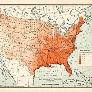
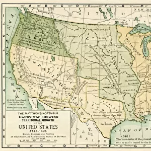
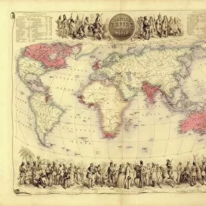
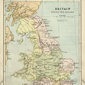
Political Map of United States 1895

![]()
Wall Art and Photo Gifts from Fine Art Storehouse
Political Map of United States 1895
The Rand-McNally Grammar School Geography 1895 - Chicago & New York
Unleash your creativity and transform your space into a visual masterpiece!
THEPALMER
Media ID 14824613
© This content is subject to copyright
Canada Mexico North America United States
FEATURES IN THESE COLLECTIONS
> Arts
> Artists
> M
> Mexican School Mexican School
> Fine Art Storehouse
> Map
> Historical Maps
> Fine Art Storehouse
> Map
> USA Maps
> Maps and Charts
> Related Images
> North America
> Canada
> Maps
> North America
> Canada
> Related Images
> North America
> Mexico
> Related Images
> North America
> Related Images
> North America
> United States of America
> Maps
> North America
> United States of America
> New Mexico
> Related Images
> North America
> United States of America
> New York
> New York
> Maps
EDITORS COMMENTS
In this print titled "Political Map of United States 1895" we are transported back in time to an era when cartography was both a science and an art form. The map, sourced from "The Rand-McNally Grammar School Geography 1895" publication, showcases the intricate details and craftsmanship that went into creating such educational tools. As our eyes wander across the image, we are greeted with a wealth of information about the political landscape of North America during that period. The borders delineating the United States, Canada, and Mexico are clearly defined, reminding us of the historical context in which these nations existed at that time. The meticulousness with which each state is labeled allows us to appreciate the attention given to accuracy and precision. It serves as a reminder of how geography education has evolved over time while highlighting its importance in understanding our world's past. "The Political Map of United States 1895" is not just a visual representation; it carries within it stories of exploration, colonization, and nation-building. This print by THEPALMER invites us to reflect on how far we have come since then while acknowledging the complexities that shaped our continent's history. Whether displayed in classrooms or homes alike, this artwork sparks curiosity and encourages dialogue about our shared heritage. Its timeless appeal lies not only in its aesthetic charm but also in its ability to transport us back to an era long gone yet forever imprinted on this beautifully crafted map.
MADE IN THE USA
Safe Shipping with 30 Day Money Back Guarantee
FREE PERSONALISATION*
We are proud to offer a range of customisation features including Personalised Captions, Color Filters and Picture Zoom Tools
SECURE PAYMENTS
We happily accept a wide range of payment options so you can pay for the things you need in the way that is most convenient for you
* Options may vary by product and licensing agreement. Zoomed Pictures can be adjusted in the Cart.