Home > Europe > United Kingdom > England > Norfolk > Belton
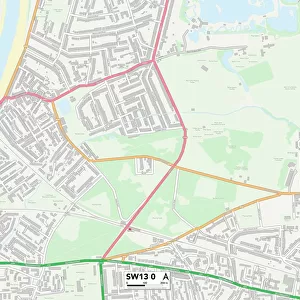
Boston PE21 9 Map

![]()
Wall Art and Photo Gifts from Map Marketing
Boston PE21 9 Map
Postcode Sector Map of Boston PE21 9
Media ID 19978029
Bakers Lane Belton Close Blackthorn Lane Boston Browns Road Buckingham Close Burrows Close Burton Close Castle Road Charter Close Cromwell Close Davey Close Elizabeth Road Fairfax Close Foster Street Green Lane Greenwood Drive Harewood Close Hartley Street Hilda Street Horncastle Road Hospital Lane Jubilee Avenue Linden Court Linden Way Locksley Close Margaret Drive Maud Street Mayfair Gardens Norfolk Place Norman Drive Oak Crescent Orchard Grove Priory Court Queens Road Richmond Close Riverside Rowan Way Sandringham Gardens Sherwood Avenue Sinclair Close Spilsby Road St Leonards Close Stafford Street The Close The Moorings Tower Road Tudor Drive Wainfleet Road Willoughby Road Colindale
FEATURES IN THESE COLLECTIONS
> Animals
> Birds
> Passerines
> Australian Robins
> Red Capped Robin
> Animals
> Fishes
> B
> Blue Whiting
> Architecture
> Towers
> Castles
> Arts
> Landscape paintings
> Forest and woodland scenes
> Forest artwork
> Europe
> United Kingdom
> England
> Norfolk
> Belton
> Europe
> United Kingdom
> England
> Norfolk
> Related Images
> Europe
> United Kingdom
> England
> Norfolk
> Sandringham
> Europe
> United Kingdom
> Scotland
> Aberdeenshire
> Maud
> Map Marketing
> Postcode Sector Maps
> PE - Peterborough
MADE IN THE USA
Safe Shipping with 30 Day Money Back Guarantee
FREE PERSONALISATION*
We are proud to offer a range of customisation features including Personalised Captions, Color Filters and Picture Zoom Tools
SECURE PAYMENTS
We happily accept a wide range of payment options so you can pay for the things you need in the way that is most convenient for you
* Options may vary by product and licensing agreement. Zoomed Pictures can be adjusted in the Cart.