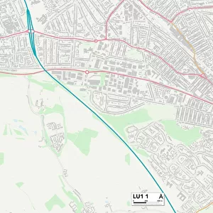
Home > Europe > United Kingdom > England > London > Boroughs > Hounslow
Hounslow W4 1 Map

![]()
Wall Art and Photo Gifts from Map Marketing
Hounslow W4 1 Map
Postcode Sector Map of Hounslow W4 1
Media ID 19980990
Alexandra Road Bath Road Bedford Road Blandford Road Blenheim Road Brookfield Road Cleveland Avenue Elliott Road Fairfax Road Fielding Road Fishers Lane Gainsborough Road Hamilton Road Hatfield Road Hawkshead Road Hounslow Lonsdale Road Marlborough Crescent Mayfield Avenue Merton Avenue Newton Grove Orchard Place Priory Avenue Priory Gardens Roman Road Rugby Road Rupert Road Shirley Road South Parade Southfield Road St Georges Road The Avenue The Orchard Thornton Avenue Windmill Road Woodstock Road Worcester Drive Bedford Park Turnham Green
FEATURES IN THESE COLLECTIONS
> Arts
> Artists
> F
> Newton Fielding
> Europe
> United Kingdom
> England
> Cleveland
> Europe
> United Kingdom
> England
> London
> Boroughs
> Hounslow
> Europe
> United Kingdom
> England
> London
> Boroughs
> Merton
> Europe
> United Kingdom
> Scotland
> Strathclyde
> Hamilton
> Europe
> United Kingdom
> Scotland
> Strathclyde
> Saltcoats
> Map Marketing
> Postcode Sector Maps
> W - London W
> Maps and Charts
> Related Images
MADE IN THE USA
Safe Shipping with 30 Day Money Back Guarantee
FREE PERSONALISATION*
We are proud to offer a range of customisation features including Personalised Captions, Color Filters and Picture Zoom Tools
SECURE PAYMENTS
We happily accept a wide range of payment options so you can pay for the things you need in the way that is most convenient for you
* Options may vary by product and licensing agreement. Zoomed Pictures can be adjusted in the Cart.