Home > Europe > United Kingdom > England > Somerset > Holford
Merthyr Tydfil CF48 2 Map

![]()
Wall Art and Photo Gifts from Map Marketing
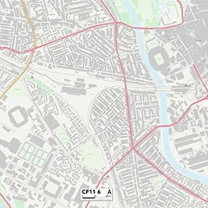
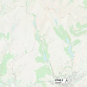
Merthyr Tydfil CF48 2 Map
Postcode Sector Map of Merthyr Tydfil CF48 2
Media ID 19966672
Amelia Close Ash Grove Beechwood Avenue Brewery Lane Cherry Tree Close Edward Street Hawthorn Hill Heol Y Mynydd High Street High Trees Hornbeam Close Jobs Lane Jones Street King Street Linden Way Llwyn Onn Maple Crescent Merthyr Tydfil Old Chapel Road Old Church Street Poplar Place Queen Street Somerset Close South Terrace St Johns Close Station Road Sycamore Crescent The Copse The Green The Hawthorns The Rise Upper High Street Wern Road Whitebeam Close Pant Triangle
FEATURES IN THESE COLLECTIONS
> Arts
> Artists
> H
> John Hillers
> Arts
> Artists
> H
> John Hills
> Europe
> United Kingdom
> England
> Somerset
> Ash
> Europe
> United Kingdom
> England
> Somerset
> Cross
> Europe
> United Kingdom
> England
> Somerset
> Holford
> Europe
> United Kingdom
> England
> Somerset
> Related Images
> Europe
> United Kingdom
> England
> Somerset
> Street
> Europe
> United Kingdom
> Wales
> Mid Glamorgan
> Merthyr Tydfil
> Europe
> United Kingdom
> Wales
> Powys
> Brecon
> Map Marketing
> Postcode Sector Maps
> CF - Cardiff
> Maps and Charts
> Related Images
MADE IN THE USA
Safe Shipping with 30 Day Money Back Guarantee
FREE PERSONALISATION*
We are proud to offer a range of customisation features including Personalised Captions, Color Filters and Picture Zoom Tools
SECURE PAYMENTS
We happily accept a wide range of payment options so you can pay for the things you need in the way that is most convenient for you
* Options may vary by product and licensing agreement. Zoomed Pictures can be adjusted in the Cart.