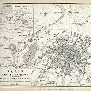
Home > Europe > France > Maps
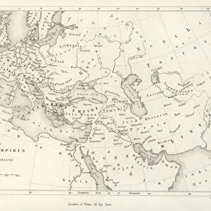
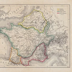
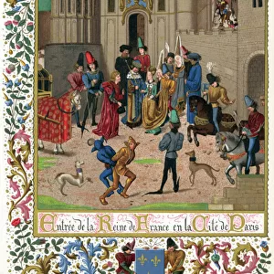
The Empire of Charlemagne, from Atlas Historique et Pittoresque

![]()
Wall Art and Photo Gifts from Fine Art Finder
The Empire of Charlemagne, from Atlas Historique et Pittoresque
XEE3481396 The Empire of Charlemagne, from Atlas Historique et Pittoresque, by M J-H Schnitzler, 1857 (colour litho) by French School, (18th century); Private Collection; Stefano Bianchetti; French, out of copyright
Media ID 22442978
© Stefano Bianchetti / Bridgeman Images
Ages Atlas Charlemagne Frankish Franks King Of The Franks Middle Territory
FEATURES IN THESE COLLECTIONS
> Arts
> Art Movements
> Medieval Art
> Fine Art Finder
> Artists
> French School
> Fine Art Finder
> Artists
> Willem Blaeu
> Fine Art Finder
> Maps (celestial & Terrestrial)
> Maps and Charts
> Related Images
EDITORS COMMENTS
This print showcases "The Empire of Charlemagne" from the renowned Atlas Historique et Pittoresque, created by M J-H Schnitzler in 1857. The vivid colors and intricate details bring to life the grandeur and vastness of Charlemagne's empire during medieval times. In this mesmerizing artwork, we are transported back to a time when Europe was ruled by a powerful king known as the King of the Franks. Charlemagne's dominion extended far and wide, encompassing territories that spanned across various regions. This map provides us with an invaluable glimpse into the historical significance and territorial expanse of his empire. As we delve deeper into this visual masterpiece, we can appreciate how cartography played a crucial role in documenting history and understanding political boundaries during those times. It serves as a testament to human ingenuity and curiosity about our world. "The Empire of Charlemagne" is not just a mere depiction of landmasses; it represents an era characterized by royal authority, European unity, and cultural exchange. Through this image, we gain insight into the Middle Ages - an epoch marked by both turbulence and progress. This rare gem from Stefano Bianchetti's private collection reminds us that maps are not only tools for navigation but also windows into our past. It invites us to explore further, unraveling stories hidden within its borders while appreciating the artistry behind its creation.
MADE IN THE USA
Safe Shipping with 30 Day Money Back Guarantee
FREE PERSONALISATION*
We are proud to offer a range of customisation features including Personalised Captions, Color Filters and Picture Zoom Tools
SECURE PAYMENTS
We happily accept a wide range of payment options so you can pay for the things you need in the way that is most convenient for you
* Options may vary by product and licensing agreement. Zoomed Pictures can be adjusted in the Cart.