Home > Europe > United Kingdom > England > Yorkshire > Dalton
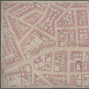
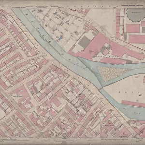
Ordnance Survey Map, Brookhill area, Sheffield, 1889 (sheet no. Yorkshire No. 294.7.19)
")
![]()
Wall Art and Photo Gifts from Sheffield City Archives
Ordnance Survey Map, Brookhill area, Sheffield, 1889 (sheet no. Yorkshire No. 294.7.19)
This map features
Top left: Weston Street, Yardley Street, Sutton Street, Bolsover Street, Brightmore Street, Mitchell Street, Winter Street, Lodge on Winter Street, Reliance Place, West Grove Place, Robertshaw Street, Sutton Cottage Lodge, Weston Park (part), Star and Garter Hotel Public House, Weston Street, Methodist Chapel (Wesleyan Reform), [Weston Street], [Edwin Terry, knife manufacturer], Reliance Works (cutlery), Bolsover Street, Imperial Hotel Public House, [Stephen Fisher and Co. malleable iron castings], Pelham Works (iron) (part), Mitchell Street.
Top right: Brightmore Street, Mitchell Street, , Robertshaw Street, Sarah Street, Upper St. Philips Road, Upper Allen Street, Beet Street, Brook Lane, New Edward Street, Siddall Street, Solly Lane, Solly Street, Brook Street, Brook Villa, Clyde Steel Works, Beet Street, Broad Lane, [St George's National] School, [Howell and Co. Ltd. steel manufacturers], Brook Steel Works, Brook Lane, Bay Horse Public House, The Albion Public House, Post Office on corner of Upper Allen Street and Mitchell Street, Woodman Inn, White Horse Public House, Brook View, St. George's Place, Brightmore Place, Ostrich Inn.
Bottom left: Western Bank, Brook Hill, Winter Street, Reliance Place, West Grove Place [Westgrove Place], Chantrey Road, The Leavy Greave, Houndsfield Road [Hounsfield Road], Leavy Greave Road, Chantrey House, St. George's Vicarage, St. Jude's Vicarage, St. Paul's Vicarage, Westbourne Villa, Brookhill House, Weston Terrace, Leavy Greave House, Ivy House, East View.
Bottom right: Brook Hill, Leavy Greave Road, Brook Villa, Broad Lane, Brook View, St. George's Place, Caledonian Terrace, Brook House, Brook Place, Upper Hanover Street, Gell Street, Victoria Street, Regent Street, St. George's Terrace, St. George's Church, Regent Lane, [Alfred V. Stacey, cutlery manufacturer], Victoria Works (cutlery), Victoria Street, Victoria Street Works (curtain rollers), Portobello Tavern, Catholic Apostolic Church, Jessop Hospital for Women, St. James's Vicarage, Dalton Terrace, [A. Beardshaw and Co. electroplate manufacturers], electroplate works.
Surveyed 1889.
Dimensions of original 77 x 102 cm.
Scale 10.56 feet : 1 mile [1:500].
From an original at Sheffield Libraries: q00062 (sheet no. Yorkshire No. 294.7.19)
Sheffield City Archives and Local Studies Library has an unrivalled collection of images of Sheffield, England
Media ID 33300933
© Sheffield City Council - All Rights Reserved
Old Map Ordnance Survey Os Map Sheffield
FEATURES IN THESE COLLECTIONS
> Animals
> Birds
> Ostriches
> Related Images
> Animals
> Farm
> Horses
> Related Images
> Animals
> Mammals
> Horse
> Related Images
> Arts
> Artists
> D
> Alfred
> Related Images
> Europe
> United Kingdom
> England
> Yorkshire
> Dalton
> Europe
> United Kingdom
> England
> Yorkshire
> Sheffield
> Europe
> United Kingdom
> England
> Yorkshire
> Street
> Europe
> United Kingdom
> England
> Yorkshire
> Sutton
> Maps and Charts
> Star Charts
> Sheffield City Archives
> Maps and Plans
> Sheffield OS maps
EDITORS COMMENTS
This print showcases an Ordnance Survey Map of the Brookhill area in Sheffield, dating back to 1889. The map, identified as sheet number Yorkshire No. 294.7.19, offers a fascinating glimpse into the city's past. The top left corner of the map reveals a bustling neighborhood with streets like Weston Street, Yardley Street, Sutton Street, Bolsover Street, and Brightmore Street. Notable landmarks include the Star and Garter Hotel Public House and Methodist Chapel (Wesleyan Reform). Industrial sites such as Reliance Works for cutlery production and Stephen Fisher & Co. 's malleable iron castings can also be spotted. Moving to the top right section of the map, we discover more streets like Robertshaw Street and Sarah Street. The area is dotted with various establishments including schools like St George's National School and steel manufacturers Howell & Co Ltd. , along with pubs such as Bay Horse Public House and White Horse Public House. The bottom left portion highlights Western Bank leading to Winter Street and West Grove Place. Vicarages for St George's Church are present alongside notable residences like Chantrey House and Ivy House. Finally, in the bottom right corner lies Upper Hanover Street intersecting with Victoria Street where Alfred V. Stacey's cutlery manufacturing business operated alongside other significant locations such as Jessop Hospital for Women. Measuring at an impressive 77 x 102 cm in its original form, this detailed map was surveyed in 1889 using a scale of 10.56 feet:1 mile (1:500). Preserved within Sheffield Libraries' archives under reference q00062 (sheet no. Yorkshire No. 294.7), this historical artifact provides invaluable insights into Sheffield's urban landscape over a century ago.
MADE IN THE USA
Safe Shipping with 30 Day Money Back Guarantee
FREE PERSONALISATION*
We are proud to offer a range of customisation features including Personalised Captions, Color Filters and Picture Zoom Tools
SECURE PAYMENTS
We happily accept a wide range of payment options so you can pay for the things you need in the way that is most convenient for you
* Options may vary by product and licensing agreement. Zoomed Pictures can be adjusted in the Cart.