Home > Europe > United Kingdom > England > Norfolk > Related Images
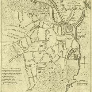
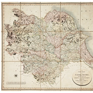
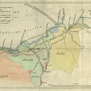
A map of Attercliffe Forge and the Farm, Tenements etc annxed thereto... belonging to the Duke of Norfolk and... Eliz Fell, 1768

![]()
Wall Art and Photo Gifts from Sheffield City Archives
A map of Attercliffe Forge and the Farm, Tenements etc annxed thereto... belonging to the Duke of Norfolk and... Eliz Fell, 1768
Includes references to River Don, weirs, Slitting Mill Dam [?Slitting Mill Lane], Brightside, John Parsons Farm, Bent Lane, Forge Dam, etc.Original at Sheffield Archives: ACM/MAPS/SheD/741
Sheffield City Archives and Local Studies Library has an unrivalled collection of images of Sheffield, England
Media ID 14049545
© Sheffield City Council
Attercliffe Brightside Farming Farms Lane Maps Mill River Rivers Road Newhall Slitting Weirs
FEATURES IN THESE COLLECTIONS
> Europe
> United Kingdom
> England
> Norfolk
> Related Images
> Maps and Charts
> Related Images
> Sheffield City Archives
> Maps and Plans
EDITORS COMMENTS
This print showcases a historical map titled "A map of Attercliffe Forge and the Farm, Tenements etc annxed thereto. . . belonging to the Duke of Norfolk and. . . Eliz Fell, 1768". The intricate details depicted in this map offer a glimpse into the past, specifically highlighting various landmarks and areas within Sheffield. The River Don takes center stage in this visual representation, with its meandering path prominently featured. Weirs can be spotted along its course, adding an element of charm to the landscape. Notably, Slitting Mill Dam (possibly connected to Slitting Mill Lane) is also marked on the map, serving as a reminder of Sheffield's industrial heritage. Brightside emerges as another focal point on this historic document. John Parsons Farm and Bent Lane are clearly identified within its boundaries. Forge Dam stands out as well, symbolizing the importance of metalworking during that era. The inclusion of Newhall Road signifies further expansion beyond Brightside towards other parts of Sheffield. This comprehensive depiction provides valuable insights into land ownership patterns during 1768 when these territories were under the control of both the Duke of Norfolk and Eliz Fell. Preserved at Sheffield Archives under reference ACM/MAPS/SheD/741, this original piece serves as a testament to our rich history. Its significance lies not only in documenting geographical features but also shedding light on farming practices prevalent at that time
MADE IN THE USA
Safe Shipping with 30 Day Money Back Guarantee
FREE PERSONALISATION*
We are proud to offer a range of customisation features including Personalised Captions, Color Filters and Picture Zoom Tools
SECURE PAYMENTS
We happily accept a wide range of payment options so you can pay for the things you need in the way that is most convenient for you
* Options may vary by product and licensing agreement. Zoomed Pictures can be adjusted in the Cart.
![A map of the lands near Attercliffe and Darnall, [?1820s]](/sq/716/map-lands-near-attercliffe-darnall-1820s-18396317.jpg.webp)
![The Duke of Norfolks estates in Brightside Bierlow, Sheffield, [mid 19th cent]](/sq/716/duke-norfolks-estates-brightside-bierlow-20355002.jpg.webp)