Home > Arts > Artists > O > Abraham Ortelius
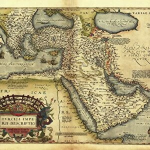
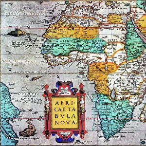
Orteliuss map of France, 1570

![]()
Wall Art and Photo Gifts from Science Photo Library
Orteliuss map of France, 1570
Orteliuss map of France. This map is from the 1570 first edition of Theatrum orbis terrarum ( Theatre of the World ). Drawn by the Flemish mapmaker Abraham Ortelius (1527-1598), and published by Gilles Coppens de Diest in Antwerp, this collection of 53 maps is considered to be the first true modern atlas
Science Photo Library features Science and Medical images including photos and illustrations
Media ID 6298369
© LIBRARY OF CONGRESS, GEOGRAPHY AND MAP DIVISION/SCIENCE PHOTO LIBRARY
1500s 1570 1570 Edition 16th Century Abraham Ortelius Age Of Discovery Antwerp Edition Cartographic Cartography Country Dutch First Edition First Modern Atlas Flemish France French Gilles Coppens De Diest Latin Latin Edition Nation Orteliuss Text Theatre Of The World Theatrum Orbis Terrarum Writing Gallia Gallic Gaul
FEATURES IN THESE COLLECTIONS
> Arts
> Artists
> O
> Abraham Ortelius
> Maps and Charts
> Abraham Ortelius
EDITORS COMMENTS
This print showcases Orteliuss map of France, a remarkable piece of cartographic artistry from the 16th century. Created by Abraham Ortelius, a renowned Flemish mapmaker, this particular map is part of the first edition of Theatrum orbis terrarum (Theatre of the World), published in 1570 by Gilles Coppens de Diest in Antwerp. Comprising a collection of 53 maps, this work is widely regarded as the inaugural true modern atlas. It offers an invaluable glimpse into European geography and history during the Age of Discovery. The intricate illustration depicts Gaul or Gallic nation, which we now know as France. Every detail on this historical artifact tells a story - from its Latin text to its meticulous depiction of geographical features and boundaries. This artwork not only serves as an essential tool for understanding past civilizations but also stands as a testament to human curiosity and exploration. As we gaze upon this masterpiece, we are transported back to an era when cartography was both an art form and a scientific endeavor. It reminds us that our world has always been shaped by those who dared to venture beyond known horizons. Science Photo Library presents this extraordinary image with utmost reverence for its historical significance and artistic beauty.
MADE IN THE USA
Safe Shipping with 30 Day Money Back Guarantee
FREE PERSONALISATION*
We are proud to offer a range of customisation features including Personalised Captions, Color Filters and Picture Zoom Tools
SECURE PAYMENTS
We happily accept a wide range of payment options so you can pay for the things you need in the way that is most convenient for you
* Options may vary by product and licensing agreement. Zoomed Pictures can be adjusted in the Cart.