Home > Animals > Mammals > Muridae > Desert Mouse
Great Salt Desert, satellite image

![]()
Wall Art and Photo Gifts from Science Photo Library
Great Salt Desert, satellite image
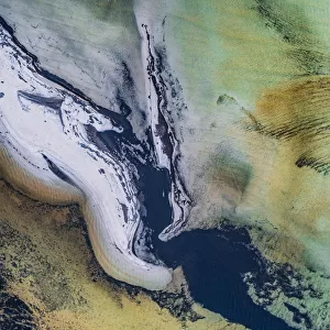
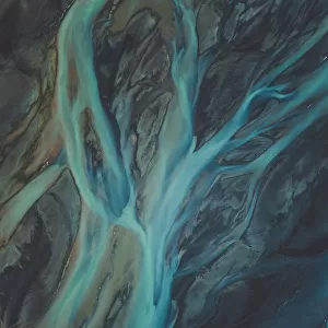
Great Salt Desert, satellite image. North is at top. Desert soil and mud is light brown, barren rocky areas are pink, and salt pans are blue. The Dasht-e Kavir (valley of desert), or Great Salt Desert, is in northern Iran, and is the largest desert in Iran. It is primarily an uninhabited wasteland, composed of mud and salt marshes covered with crusts of salt that retain a small amount of moisture. The area shown in this image is around 60 kilometres wide. The image data was obtained on 25 April 2001, by the Landsat 7 satellite
Science Photo Library features Science and Medical images including photos and illustrations
Media ID 1705489
© NASA/SCIENCE PHOTO LIBRARY
2000s 2001 April Desert Earth Observation From Space Iran Iranian Land Landsat 7 Middle East Physical Geography Rocky Salt Pan Salty Sandy Satellite Satellite Image
FEATURES IN THESE COLLECTIONS
> Animals
> Mammals
> Muridae
> Desert Mouse
> Asia
> Iran
> Related Images
> Asia
> Related Images
> Europe
> France
> Canton
> Landes
> Science Photo Library
> Aerial and Satellite
> Science
> Space Exploration
> Related Images
> Science
> Space Exploration
> Satellite Imagery
EDITORS COMMENTS
This satellite image showcases the vast expanse of the Great Salt Desert, also known as Dasht-e Kavir, in northern Iran. With its northward orientation at the top, this print reveals a stunning blend of colors that represent different features of this unique landscape. The light brown hues depict desert soil and mud, while pink shades highlight barren rocky areas. In contrast, mesmerizing blue tones symbolize salt pans scattered across the region. As the largest desert in Iran, Dasht-e Kavir is an uninhabited wasteland characterized by mud and salt marshes covered with crusts of salt. Despite its seemingly inhospitable nature, these marshes retain a small amount of moisture essential for sustaining life forms adapted to such extreme conditions. The image data captured on April 25th, 2001 by the Landsat 7 satellite offers us a glimpse into this extraordinary environment from space. Spanning approximately 60 kilometers wide, it showcases the immense scale and grandeur of this natural wonder. With its rocky terrain and sandy expanses stretching as far as the eye can see, this photograph immerses viewers in an otherworldly experience. It serves as a testament to Earth's diverse physical geography while highlighting both the beauty and harshness found within our planet's landscapes.
MADE IN THE USA
Safe Shipping with 30 Day Money Back Guarantee
FREE PERSONALISATION*
We are proud to offer a range of customisation features including Personalised Captions, Color Filters and Picture Zoom Tools
SECURE PAYMENTS
We happily accept a wide range of payment options so you can pay for the things you need in the way that is most convenient for you
* Options may vary by product and licensing agreement. Zoomed Pictures can be adjusted in the Cart.