Home > Mary Evans Prints Online > New Images August 2021
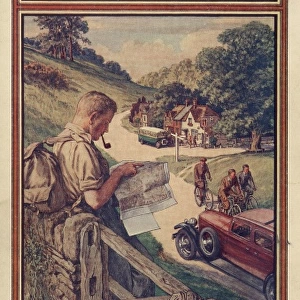
Ordnance Survey one-inch map of the Chilterns

![]()
Wall Art and Photo Gifts from Mary Evans Picture Library
Ordnance Survey one-inch map of the Chilterns
Mary Evans Picture Library makes available wonderful images created for people to enjoy over the centuries
Media ID 23086358
© Mary Evans Picture Library
EDITORS COMMENTS
1. Title: Exploring the Chilterns: A Journey Through Time with an Ordnance Survey One-inch Map The Ordnance Survey one-inch map of the Chilterns is a captivating and intriguing piece of cartographic history. One inch to the mile scale, this map offers a detailed and comprehensive view of the Chiltern Hills, an area of outstanding natural beauty located in southern England. The Chilterns, a range of chalk hills, have been a popular destination for walkers, cyclists, and nature enthusiasts for centuries. This map, produced by the Ordnance Survey, provides an essential tool for those wishing to explore the region's diverse landscapes, hidden gems, and rich heritage. The intricate details on the map reveal the complex topography of the Chilterns, from the rolling hills and wooded valleys to the winding rivers and picturesque villages. The map also includes an abundance of annotated features, such as place names, roads, footpaths, and geological formations, making it an invaluable resource for anyone planning a journey through this enchanting region. The Ordnance Survey one-inch map of the Chilterns is a testament to the rich history of cartography and the importance of accurate and detailed mapping in understanding and appreciating the natural world. The map's intricate details and meticulous accuracy offer a glimpse into the past, allowing us to trace the footsteps of those who have come before us and explore the beauty of the Chilterns in a truly authentic way. As we delve into the intricacies of this map, we are transported back in time, imagining the cartographers who painstakingly surveyed and mapped the land, and the countless explorers who have used this map to navigate the Chilterns over the years. The Ordnance Survey one-inch map of the Chilterns is not just a map, but a window into the past, a connection to the history of the region, and a reminder of the enduring allure of the great outdoors.
MADE IN THE USA
Safe Shipping with 30 Day Money Back Guarantee
FREE PERSONALISATION*
We are proud to offer a range of customisation features including Personalised Captions, Color Filters and Picture Zoom Tools
SECURE PAYMENTS
We happily accept a wide range of payment options so you can pay for the things you need in the way that is most convenient for you
* Options may vary by product and licensing agreement. Zoomed Pictures can be adjusted in the Cart.