Home > Arts > Artists > F > Giulio Ferrario
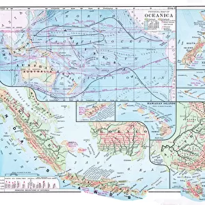
Map of Oceania and the southern Pacific by

![]()
Wall Art and Photo Gifts from Mary Evans Picture Library
Map of Oceania and the southern Pacific by
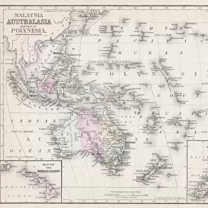
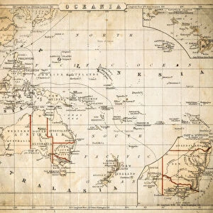
Map of Oceania and the southern Pacific by Bartolomeo Borghi, Florence, 1836. Handcoloured copperplate engraving from Giulio Ferrarios Ancient and Modern Costumes of all the Peoples of the World, Florence, Italy, 1844
Mary Evans Picture Library makes available wonderful images created for people to enjoy over the centuries
Media ID 23173876
© Florilegius/Mary Evans
Bartolomeo Chart Ferrario Giulio Oceania Pacific Peoples Southern
FEATURES IN THESE COLLECTIONS
> Arts
> Artists
> F
> Giulio Ferrario
> Europe
> Italy
> Related Images
> Europe
> Italy
> Tuscany
> Florence
> Maps and Charts
> Early Maps
> Maps and Charts
> Italy
> Maps and Charts
> Related Images
> Mary Evans Prints Online
> New Images August 2021
EDITORS COMMENTS
This stunning and intricately detailed map print, titled "Map of Oceania and the Southern Pacific," is an exquisite example of cartographic artistry from the 19th century. Created by Bartolomeo Borghi in Florence, Italy, in 1836, this handcoloured copperplate engraving was later published in Giulio Ferrario's "Ancient and Modern Costumes of all the Peoples of the World" in 1844. The map provides a comprehensive view of the vast Oceania region and the southern Pacific, featuring an impressive level of detail for the time. The intricate depiction of the various islands and archipelagos is accompanied by carefully labelled names and geographical features. The map also includes illustrations of indigenous peoples from the region, adding a cultural dimension to the cartographic representation. Borghi's map is a testament to the meticulous craftsmanship of the time, with each element carefully etched and handcoloured to create a visually stunning and informative piece. The use of copperplate engraving, a technique that involved etching the design onto a copper plate and then transferring it to paper through the use of ink and pressure, ensured a high level of detail and precision. This map offers a fascinating glimpse into the cartographic knowledge of the mid-19th century, as well as providing a visual representation of the rich cultural diversity of Oceania and the southern Pacific. With its intricate details and beautiful handcolouring, Borghi's map remains an impressive and captivating work of art and historical significance.
MADE IN THE USA
Safe Shipping with 30 Day Money Back Guarantee
FREE PERSONALISATION*
We are proud to offer a range of customisation features including Personalised Captions, Color Filters and Picture Zoom Tools
SECURE PAYMENTS
We happily accept a wide range of payment options so you can pay for the things you need in the way that is most convenient for you
* Options may vary by product and licensing agreement. Zoomed Pictures can be adjusted in the Cart.