Map of the Mediterranean (Add. Ms. 25691). It
. It")
![]()
Wall Art and Photo Gifts from Mary Evans Picture Library
Map of the Mediterranean (Add. Ms. 25691). It
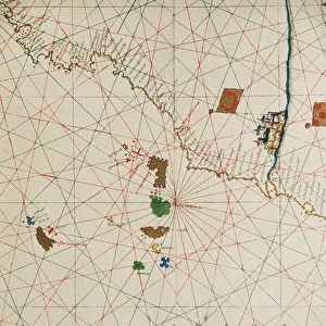
Map of the Mediterranean (Add.Ms. 25691). It is probably the oldest portolan chart from the school of Mallorca ca. 1327-1330. Are represented Italy, Sicily and North Africa. Miniature Painting. UNITED KINGDOM. London. The British Museum
Mary Evans Picture Library makes available wonderful images created for people to enjoy over the centuries
Media ID 8283811
© Mary Evans/Iberfoto
Chart Mallorca Mediterranean Oldest Portolan Represented Sicily
EDITORS COMMENTS
This exquisite miniature painting, known as the Map of the Mediterranean (Add. Ms. 25691), is believed to be the oldest portolan chart originating from the School of Mallorca, dating back to approximately 1327-1330. The intricately detailed map showcases the Mediterranean Sea and its surrounding regions, including Italy, Sicily, and North Africa. The School of Mallorca, a significant center for cartography during the late Middle Ages, is renowned for its innovative approach to mapmaking. This map, with its horizontal orientation, represents a significant departure from the traditional T-O and mappa mundi designs of the time. Instead, it employs a more accurate representation of the Mediterranean's geography, featuring a grid system and detailed coastal outlines. Italy is depicted in the center of the map, with Sicily located to the south. To the west, the Iberian Peninsula is shown, while North Africa is represented to the south. The map's intricate detail extends to the depiction of various islands in the Mediterranean, such as Sardinia, Corsica, and Malta. The British Museum in London is the current home of this precious historical artifact. Its acquisition by the museum is a testament to the institution's commitment to preserving and showcasing the world's cultural heritage. The Map of the Mediterranean (Add. Ms. 25691) offers a fascinating glimpse into the cartographic knowledge of the medieval world and the early development of European mapmaking.
MADE IN THE USA
Safe Shipping with 30 Day Money Back Guarantee
FREE PERSONALISATION*
We are proud to offer a range of customisation features including Personalised Captions, Color Filters and Picture Zoom Tools
SECURE PAYMENTS
We happily accept a wide range of payment options so you can pay for the things you need in the way that is most convenient for you
* Options may vary by product and licensing agreement. Zoomed Pictures can be adjusted in the Cart.