Map of the French Department of Loiret - No. 45

![]()
Wall Art and Photo Gifts from Mary Evans Picture Library
Map of the French Department of Loiret - No. 45
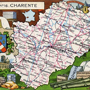
Map of the French Department of Loiret - No.45, featuring inset illustrations depicting Sully sur Loire, ceramics from Gien, foodstuffs from Orleans and an inset portrait of Gaspard II de Coligny, Seigneur de Chatillon, a 16th century French nobleman and admiral, best remembered as a disciplined Huguenot leader in the French Wars of Religion.
circa 1910s
Mary Evans Picture Library makes available wonderful images created for people to enjoy over the centuries
Media ID 14363904
© The Roseries Collection / Mary Evans Picture Library
Admiral Ceramics Chart Chatillon Coligny Crest Department Foodstuffs Gaspard Huguenot Loire Nobleman Orleans Plan Produce Seigneur Sully Wars Gien Loiret
EDITORS COMMENTS
This elegant and intricately detailed map print, number 45 in The Roseries Collection, showcases the French Department of Loiret from the 1910s. The map is adorned with inset illustrations that highlight the historical and cultural significance of the region. At the top left, an illustration of Sully sur Loire, a picturesque town located on the right bank of the Loire River, is depicted. Known for its Renaissance-era château and beautiful gardens, Sully sur Loire has long been a popular destination for tourists and history enthusiasts. To the right of the map, three inset illustrations showcase various aspects of Loiret's rich heritage. The first illustration features ceramics from Gien, a town renowned for its fine earthenware production since the 16th century. The second illustration showcases foodstuffs from Orleans, the historic capital city of the Loiret region, known for its culinary traditions and local produce. The third illustration features an inset portrait of Gaspard II de Coligny, Seigneur de Chatillon, a 16th-century French nobleman and admiral. Best remembered as a disciplined Huguenot leader in the French Wars of Religion, Gaspard II de Coligny played a significant role in the defense of the Protestant cause during the religious conflicts that plagued France in the late 16th century. His leadership and military prowess earned him the respect and admiration of both his allies and enemies. This map print serves as a testament to the rich history and cultural significance of the Loiret region, showcasing its beautiful landscapes, historical sites, and notable figures.
MADE IN THE USA
Safe Shipping with 30 Day Money Back Guarantee
FREE PERSONALISATION*
We are proud to offer a range of customisation features including Personalised Captions, Color Filters and Picture Zoom Tools
SECURE PAYMENTS
We happily accept a wide range of payment options so you can pay for the things you need in the way that is most convenient for you
* Options may vary by product and licensing agreement. Zoomed Pictures can be adjusted in the Cart.