Home > Europe > United Kingdom > England > Shropshire > Bagley
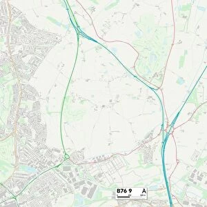
Shropshire SY12 9 Map

![]()
Wall Art and Photo Gifts from Map Marketing
Shropshire SY12 9 Map
Postcode Sector Map of Shropshire SY12 9
Media ID 19982616
Almond Drive Brow Lane Cedar Avenue Chapel Lane Cherry Drive Chestnut Avenue Church Lane College Close Cross Lanes Eaton Court Ellesmere Road Elm Close Elm Court Farm Lane Firtree Close Fox Close Grange Road Hill Crescent Hill Park Holly Close Horseshoe Lane Larch Close Lime Close Magnolia Drive Maple Avenue Moss Lane Mulberry Avenue Pine Close Robin Close Rowan Close Shop Lane Shropshire Spruce Close The Hawthorns Wisteria Way Elson Newnes
FEATURES IN THESE COLLECTIONS
> Europe
> United Kingdom
> England
> Shropshire
> Bagley
> Europe
> United Kingdom
> England
> Shropshire
> Eaton
> Europe
> United Kingdom
> England
> Shropshire
> Ellesmere
> Europe
> United Kingdom
> England
> Shropshire
> Gravels
> Europe
> United Kingdom
> England
> Shropshire
> Lee
> Europe
> United Kingdom
> England
> Shropshire
> Marton
> Europe
> United Kingdom
> England
> Shropshire
> Related Images
> Map Marketing
> Postcode Sector Maps
> SY - Shrewsbury
> Maps and Charts
> Related Images
MADE IN THE USA
Safe Shipping with 30 Day Money Back Guarantee
FREE PERSONALISATION*
We are proud to offer a range of customisation features including Personalised Captions, Color Filters and Picture Zoom Tools
SECURE PAYMENTS
We happily accept a wide range of payment options so you can pay for the things you need in the way that is most convenient for you
* Options may vary by product and licensing agreement. Zoomed Pictures can be adjusted in the Cart.