Home > Europe > United Kingdom > Wales > Pembrokeshire > St Davids
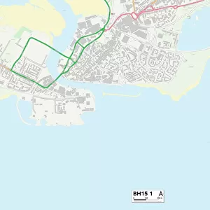
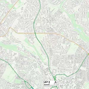
Poole BH16 6 Map

![]()
Wall Art and Photo Gifts from Map Marketing
Poole BH16 6 Map
Postcode Sector Map of Poole BH16 6
Media ID 19965534
Ash Avenue Ash Close Ballard Close Beacon Hill Beech Avenue Birch Avenue Chestnut Avenue Dorchester Road Fir Avenue Glebe Road Halls Road High Street Holton Road Jasmine Court Laurel Avenue Lime Kiln Road Middle Road Mill Lane New Road Old Forge Close Orchard Close Orchid Court Paddock Close Park Drive Penrose Close Pine Crescent Poole Prospect Road Purbeck Close Purbeck Road Rose Court Sandford Road Sandy Lane St Davids Road Station Road Stuart Close Sycamore Avenue The Spinney Vineyard Close Wareham Road Warren Way Willow Crescent Wimborne Road
FEATURES IN THESE COLLECTIONS
> Animals
> Mammals
> Bovidae
> Goral
> Animals
> Mammals
> Muridae
> Heath Mouse
> Arts
> Artists
> M
> David Martin
> Europe
> France
> Canton
> Landes
> Europe
> United Kingdom
> Wales
> Pembrokeshire
> St Davids
> Map Marketing
> Postcode Sector Maps
> BH - Bournemouth
> Maps and Charts
> Related Images
> North America
> Saint Martin
> Maps
MADE IN THE USA
Safe Shipping with 30 Day Money Back Guarantee
FREE PERSONALISATION*
We are proud to offer a range of customisation features including Personalised Captions, Color Filters and Picture Zoom Tools
SECURE PAYMENTS
We happily accept a wide range of payment options so you can pay for the things you need in the way that is most convenient for you
* Options may vary by product and licensing agreement. Zoomed Pictures can be adjusted in the Cart.