Home > Europe > United Kingdom > England > London > Museums > British Library
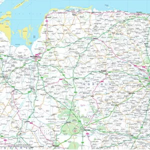
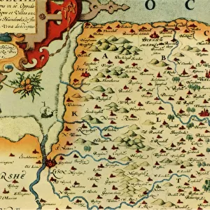
Saxtons Map of Norfolk, 1574, (1944). Creator: Christopher Saxton
. Creator: Christopher Saxton")
![]()
Wall Art and Photo Gifts from Heritage Images
Saxtons Map of Norfolk, 1574, (1944). Creator: Christopher Saxton
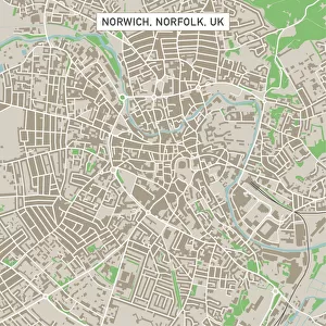
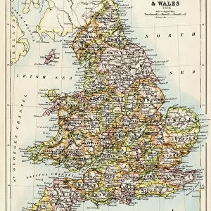
Saxtons Map of Norfolk, 1574, (1944). Detail of the county of Norfolk, showing rivers, towns and villages, and a ship in The Wash. One of 35 coloured maps in " Atlas of the Counties of England and Wales", the first atlas of any country, made by Christopher Saxton. Manuscript in the British Library in London. From " British Maps and Map-Makers", by Edward Lynam. [Collins, London, 1944]
Heritage Images features heritage image collections
Media ID 19777284
© The Print Collector/Heritage Images
Britain In Pictures Christopher Coastline Collins Edward Edward Lynam Elizabethan Lynam Norfolk Rivers Social History William Collins William Collins And Sons William Collins Sons Christopher Saxton Saxton The Wash
FEATURES IN THESE COLLECTIONS
> Animals
> Mammals
> Muridae
> Fortior
> Arts
> Artists
> C
> William Collins
> Arts
> Artists
> S
> Christopher Saxton
> Europe
> United Kingdom
> England
> London
> Museums
> British Library
> Europe
> United Kingdom
> England
> Maps
> Europe
> United Kingdom
> England
> Norfolk
> Related Images
> Europe
> United Kingdom
> England
> Rivers
> Europe
> United Kingdom
> Wales
> Maps
> Europe
> United Kingdom
> Wales
> Posters
> Europe
> United Kingdom
> Wales
> Rivers
EDITORS COMMENTS
This print showcases Saxtons Map of Norfolk from 1574, a remarkable piece of cartographic history. Created by Christopher Saxton and featured in the "Atlas of the Counties of England and Wales" this map is considered the first atlas ever made for any country. The intricate detail captured in this particular section highlights the county of Norfolk, revealing its rivers, towns, villages, and even a ship sailing through The Wash. The vibrant colors bring life to this centuries-old map, allowing us to appreciate both its artistic beauty and historical significance. Preserved as a manuscript in the British Library in London, it serves as an invaluable resource for researchers and enthusiasts alike. Edward Lynam's book "British Maps and Map-Makers" sheds light on the importance of these maps throughout British history. In this photograph print from 1944, we witness a fascinating intersection between past and present—a glimpse into how people perceived geography during Elizabethan times juxtaposed with mid-20th century Britain. As we explore this image further, we are reminded that maps not only provide geographical information but also offer insights into social history. They reflect cultural contexts while shaping our understanding of places over time. This extraordinary print invites us to delve into Norfolk's rich heritage while appreciating Christopher Saxton's pioneering work in mapping England's counties.
MADE IN THE USA
Safe Shipping with 30 Day Money Back Guarantee
FREE PERSONALISATION*
We are proud to offer a range of customisation features including Personalised Captions, Color Filters and Picture Zoom Tools
SECURE PAYMENTS
We happily accept a wide range of payment options so you can pay for the things you need in the way that is most convenient for you
* Options may vary by product and licensing agreement. Zoomed Pictures can be adjusted in the Cart.