Home > Europe > United Kingdom > England > London > Towns > Kew
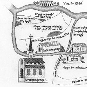
Map of Chertsey Abbey, 1432, (1944). Creator: Unknown
. Creator: Unknown")
![]()
Wall Art and Photo Gifts from Heritage Images
Map of Chertsey Abbey, 1432, (1944). Creator: Unknown
Map of Chertsey Abbey, 1432, (1944). Plan of Chertsey Abbey and estate in Surrey, showing the Benedictine monastery, Oxlake Mill, bridge over the river Thames, the village of Laleham, Burghwey Barn and Redewynd Causeway. Manuscript in the National Archives at Kew, London. From " British Maps and Map-Makers", by Edward Lynam. [Collins, London, 1944]
Heritage Images features heritage image collections
Media ID 19777280
© The Print Collector/Heritage Images
Abbey Benedictine Monastery Britain In Pictures Collins Edward Edward Lynam Estate Lynam Mill Monastery Social History Surrey Water Mill Watermill William Collins William Collins And Sons William Collins Sons Chertsey
FEATURES IN THESE COLLECTIONS
> Animals
> Mammals
> Muridae
> Fortior
> Arts
> Art Movements
> Medieval Art
> Arts
> Artists
> C
> William Collins
> Europe
> United Kingdom
> England
> London
> River Thames
> Europe
> United Kingdom
> England
> London
> Towns
> Kew
> Europe
> United Kingdom
> England
> Maps
> Europe
> United Kingdom
> England
> Rivers
> Europe
> United Kingdom
> England
> Surrey
> Chertsey
> Europe
> United Kingdom
> England
> Surrey
> Laleham
> Europe
> United Kingdom
> England
> Surrey
> Related Images
EDITORS COMMENTS
This print showcases a remarkable piece of history - the Map of Chertsey Abbey from 1432. Created by an unknown artist in 1944, this manuscript can be found in the National Archives at Kew, London. The map provides a detailed plan of Chertsey Abbey and its surrounding estate in Surrey, England. The intricate illustration reveals various significant landmarks such as the Benedictine monastery, Oxlake Mill, a bridge over the majestic River Thames, and even the quaint village of Laleham. It also highlights Burghwey Barn and Redewynd Causeway, offering insights into the medieval countryside life during that era. With vibrant colors and meticulous attention to detail, this map transports us back to the fifteenth century when Chertsey Abbey flourished as a religious center. Its presence on farmland along with its watermill signifies both its spiritual significance and economic importance within British society. As we delve into this historical artifact curated by Edward Lynam for his book "British Maps and Map-Makers" we gain valuable insights into not only geographical features but also social history. This print serves as a testament to William Collins' dedication to preserving Britain's rich heritage through their publication series "Britain in Pictures". Immerse yourself in this extraordinary glimpse into our past - witness how religion intertwined with daily life amidst stunning landscapes captured within this exquisite map from centuries ago.
MADE IN THE USA
Safe Shipping with 30 Day Money Back Guarantee
FREE PERSONALISATION*
We are proud to offer a range of customisation features including Personalised Captions, Color Filters and Picture Zoom Tools
SECURE PAYMENTS
We happily accept a wide range of payment options so you can pay for the things you need in the way that is most convenient for you
* Options may vary by product and licensing agreement. Zoomed Pictures can be adjusted in the Cart.