Home > Aerial Photography > Related Images
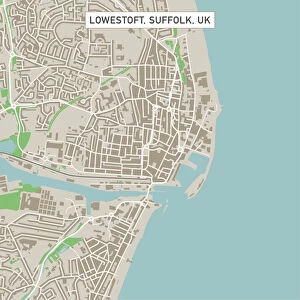
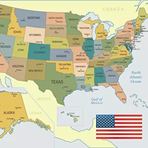
Laramie Wyoming US City Street Map

![]()
Wall Art and Photo Gifts from Fine Art Storehouse
Laramie Wyoming US City Street Map
Vector Illustration of a City Street Map of Laramie, Wyoming, USA. Scale 1:60, 000.
All source data is in the public domain.
U.S. Geological Survey, US Topo
Used Layers:
USGS The National Map: National Hydrography Dataset (NHD)
USGS The National Map: National Transportation Dataset (NTD)
Unleash your creativity and transform your space into a visual masterpiece!
Frank Ramspott
Media ID 15054945
© Frank Ramspott, all rights reserved
Aerial View City Map Computer Graphic Directly Above Downtown District Gray Road Map Text Wyoming Digitally Generated Image Green Color Laramie White Color
FEATURES IN THESE COLLECTIONS
> Aerial Photography
> Related Images
> Animals
> Insects
> Hemiptera
> Green Scale
> Arts
> Contemporary art
> Digital artwork
> Street art
> Arts
> Landscape paintings
> Waterfall and river artworks
> River artworks
> Arts
> Portraits
> Pop art gallery
> Street art portraits
> Arts
> Street art graffiti
> Digital art
> Digital paintings
> Arts
> Street art graffiti
> Digital art
> Vector illustrations
> Fine Art Storehouse
> Map
> Street Maps
> Fine Art Storehouse
> Map
> USA Maps
> Maps and Charts
> Geological Map
> Maps and Charts
> Related Images
> North America
> United States of America
> Lakes
> Related Images
EDITORS COMMENTS
This print showcases the intricate details of Laramie, Wyoming's city street map in a stunning vector illustration. With a scale of 1:60,000, every road and landmark is meticulously depicted, offering an immersive experience for any viewer. The artist, Frank Ramspott, has utilized various layers from publicly available data sources such as the U. S. Geological Survey and US Topo to create this visually striking piece. The composition highlights the downtown district with its bustling streets and vibrant energy. A serene lake gracefully winds through the landscape while a river meanders alongside it, adding a touch of tranquility to the urban setting. The color palette chosen by Ramspott beautifully captures the essence of Laramie; shades of gray symbolize its industrial heritage while blue represents its natural surroundings. From directly above, this digitally generated image provides an aerial view that allows one to appreciate the city's layout and design on a grand scale. Text elements are strategically placed throughout the artwork to provide additional context without overwhelming its overall aesthetic appeal. Ideal for lovers of cartography or those with an affinity for their hometowns, this print effortlessly combines artistry with geographic accuracy. It serves as both a decorative piece and an informative tool that invites exploration into Laramie's physical geography. Whether displayed in homes or offices, this unique artwork will surely captivate viewers with its intricate details and timeless charm.
MADE IN THE USA
Safe Shipping with 30 Day Money Back Guarantee
FREE PERSONALISATION*
We are proud to offer a range of customisation features including Personalised Captions, Color Filters and Picture Zoom Tools
SECURE PAYMENTS
We happily accept a wide range of payment options so you can pay for the things you need in the way that is most convenient for you
* Options may vary by product and licensing agreement. Zoomed Pictures can be adjusted in the Cart.