Home > Aerial Photography > Related Images
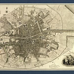
Duluth Minnesota US City Street Map

![]()
Wall Art and Photo Gifts from Fine Art Storehouse
Duluth Minnesota US City Street Map
Vector Illustration of a City Street Map of Duluth, Minnesota, USA. Scale 1:60, 000.
All source data is in the public domain.
U.S. Geological Survey, US Topo
Used Layers:
USGS The National Map: National Hydrography Dataset (NHD)
USGS The National Map: National Transportation Dataset (NTD)
Unleash your creativity and transform your space into a visual masterpiece!
Frank Ramspott
Media ID 15215812
© Frank Ramspott, all rights reserved
Aerial View City Map Computer Graphic Directly Above Downtown District Gray Harbor Lake Superior Minnesota Road Map Text Digitally Generated Image Duluth Green Color White Color
FEATURES IN THESE COLLECTIONS
> Aerial Photography
> Related Images
> Animals
> Insects
> Hemiptera
> Green Scale
> Arts
> Contemporary art
> Digital artwork
> Street art
> Arts
> Landscape paintings
> Waterfall and river artworks
> River artworks
> Arts
> Portraits
> Pop art gallery
> Street art portraits
> Arts
> Street art graffiti
> Digital art
> Digital paintings
> Arts
> Street art graffiti
> Digital art
> Vector illustrations
> Fine Art Storehouse
> Map
> Street Maps
> Fine Art Storehouse
> Map
> USA Maps
> Maps and Charts
> Geological Map
> Maps and Charts
> Related Images
> North America
> United States of America
> Lakes
> Lake Superior
EDITORS COMMENTS
This print showcases a meticulously detailed vector illustration of Duluth, Minnesota's city street map. With a scale of 1:60,000, every intricate detail is brought to life in this stunning artwork. The image encompasses the essence of Duluth, with its picturesque location on Lake Superior and its bustling downtown district. Created by Frank Ramspott using publicly available source data from the U. S. Geological Survey and US Topo, this piece highlights the beauty of cartography and design. The layers used include the National Hydrography Dataset (NHD) and National Transportation Dataset (NTD), providing an accurate representation of the city's roads, rivers, and harbor. The digitally generated image offers an aerial view directly above Duluth, allowing viewers to appreciate its physical geography in vivid color. Shades of gray, blue, white, and green bring depth to the composition while text provides additional context for orientation. With no people present in the scene, all attention is drawn to the intricacies of this urban landscape. This print serves as both a decorative piece for any art enthusiast or a valuable resource for those interested in exploring Duluth's streetscape
MADE IN THE USA
Safe Shipping with 30 Day Money Back Guarantee
FREE PERSONALISATION*
We are proud to offer a range of customisation features including Personalised Captions, Color Filters and Picture Zoom Tools
SECURE PAYMENTS
We happily accept a wide range of payment options so you can pay for the things you need in the way that is most convenient for you
* Options may vary by product and licensing agreement. Zoomed Pictures can be adjusted in the Cart.