Home > Maps and Charts > Early Maps
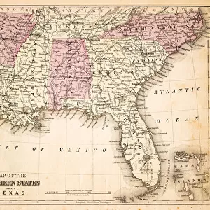
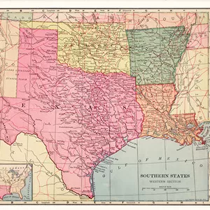
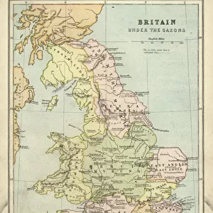
Map Southern States 1888

![]()
Wall Art and Photo Gifts from Fine Art Storehouse
Map Southern States 1888
Butlers Elementary Geography by Jacques W. Redway - Philadelphia 1888
Unleash your creativity and transform your space into a visual masterpiece!
THEPALMER
Media ID 20114725
© A 2014 Roberto Adrian Photography
FEATURES IN THESE COLLECTIONS
> Fine Art Storehouse
> Map
> Historical Maps
> Maps and Charts
> Early Maps
EDITORS COMMENTS
In this print titled "Map Southern States 1888" we are transported back in time to the late 19th century, where cartography was a meticulous art form. The map, originally featured in Jacques W. Redway's renowned educational book "Butlers Elementary Geography" takes us on a journey through the southern states of America as they were in Philadelphia during that era. The intricate details and vibrant colors of this vintage map immediately catch our attention. It beautifully showcases the diverse topography and geographical features of the region, from rolling hills to winding rivers and sprawling coastlines. As we explore each state meticulously outlined with precision, we can almost imagine ourselves embarking on an adventurous expedition across these historic lands. This particular print has been skillfully preserved by THEPALMER for Fine Art Storehouse, ensuring its longevity for generations to come. Its presence evokes nostalgia and curiosity about how life must have been like over a century ago in these southern territories. Whether displayed in a classroom or adorning the walls of a history enthusiast's study, this remarkable piece serves as both an educational tool and an exquisite work of art. It allows us to appreciate not only the craftsmanship behind historical maps but also offers a glimpse into America's past – reminding us of our rich heritage and inspiring further exploration into our nation's fascinating history.
MADE IN THE USA
Safe Shipping with 30 Day Money Back Guarantee
FREE PERSONALISATION*
We are proud to offer a range of customisation features including Personalised Captions, Color Filters and Picture Zoom Tools
SECURE PAYMENTS
We happily accept a wide range of payment options so you can pay for the things you need in the way that is most convenient for you
* Options may vary by product and licensing agreement. Zoomed Pictures can be adjusted in the Cart.