Home > Asia > Japan > Maps
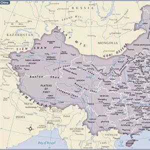
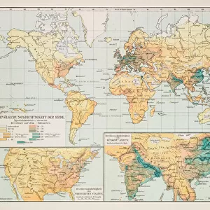
Map of China and Japan 1896

![]()
Wall Art and Photo Gifts from Fine Art Storehouse
Map of China and Japan 1896
Andres Allgemeiner Handatlas - Bielefeld und Leipzig 1896
Unleash your creativity and transform your space into a visual masterpiece!
THEPALMER
Media ID 18356845
FEATURES IN THESE COLLECTIONS
> Asia
> Japan
> Related Images
> Fine Art Storehouse
> Map
> Historical Maps
> Maps and Charts
> Related Images
EDITORS COMMENTS
This print showcases a vintage map of China and Japan from the year 1896, sourced from Andres Allgemeiner Handatlas - Bielefeld und Leipzig. With intricate details and exquisite craftsmanship, this piece takes us back in time to an era when cartography was both art and science. The map itself is a testament to the skill and dedication of its creator, THEPALMER. Every contour line, river system, mountain range, and city is meticulously depicted with precision and accuracy. The delicate shading techniques employed bring depth to the landforms while highlighting the rich cultural heritage of these two nations. China's vast expanse unfolds before our eyes as we explore its provinces, major cities like Beijing and Shanghai, ancient landmarks such as the Great Wall of China, and iconic rivers like the Yangtze. Meanwhile, Japan emerges as an archipelago bursting with character—its islands interconnected by bridges of knowledge that have shaped its history. As we gaze upon this historical artifact preserved through time on fine art paper at Fine Art Storehouse, we are reminded not only of how far cartography has evolved but also how it continues to shape our understanding of the world. This stunning print serves as a window into an era long gone yet forever etched in our collective memory—a tribute to human curiosity and exploration that transcends borders. Whether displayed in a study or adorning a living room wall, this Map of China and Japan 1896 invites us on a journey through space and time—an invitation impossible
MADE IN THE USA
Safe Shipping with 30 Day Money Back Guarantee
FREE PERSONALISATION*
We are proud to offer a range of customisation features including Personalised Captions, Color Filters and Picture Zoom Tools
SECURE PAYMENTS
We happily accept a wide range of payment options so you can pay for the things you need in the way that is most convenient for you
* Options may vary by product and licensing agreement. Zoomed Pictures can be adjusted in the Cart.