Home > Europe > United Kingdom > England > London > Related Images
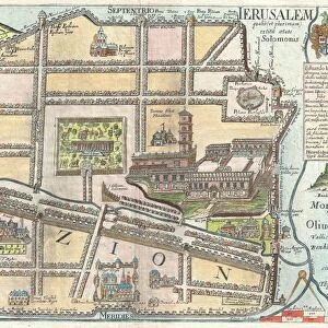
City Map of Ancient Jerusalem, from The Citizens Atlas of the World

![]()
Wall Art and Photo Gifts from Fine Art Finder
City Map of Ancient Jerusalem, from The Citizens Atlas of the World
KW287954 City Map of Ancient Jerusalem, from The Citizens Atlas of the World, published in London, c.1899 (litho) by English School, (19th century); Private Collection; Ken Welsh; English, out of copyright
Media ID 12802715
© www.bridgemanimages.com
Holy City Zion Akra Arab Quarter Bezetha Ophel
FEATURES IN THESE COLLECTIONS
> Europe
> United Kingdom
> England
> London
> Related Images
> Fine Art Finder
> Schools
> English School
EDITORS COMMENTS
This print showcases a City Map of Ancient Jerusalem, taken from The Citizens Atlas of the World. Published in London around 1899, this lithograph by the English School provides a fascinating glimpse into the intricate cartography of one of history's most significant cities. With its rich historical and cultural heritage, Jerusalem has long been revered as a holy city for Jewish, Christian, and Arab communities alike. The map highlights various quarters within ancient Jerusalem such as Zion, Akra, Ophel, Bezetha - each representing distinct neighborhoods with their own unique characteristics. This detailed representation allows viewers to immerse themselves in the city's complex urban landscape. As we explore this remarkable piece of artistry and craftsmanship preserved in a private collection today, it serves as a reminder of how maps have played an essential role throughout history. They not only guide us through physical spaces but also offer glimpses into societies' beliefs and values. Whether you are an avid historian or simply intrigued by ancient civilizations, this City Map of Ancient Jerusalem transports you back in time to experience the diverse tapestry that once thrived within these walls. It is truly awe-inspiring to witness how different cultures coexisted harmoniously within this sacred space centuries ago.
MADE IN THE USA
Safe Shipping with 30 Day Money Back Guarantee
FREE PERSONALISATION*
We are proud to offer a range of customisation features including Personalised Captions, Color Filters and Picture Zoom Tools
SECURE PAYMENTS
We happily accept a wide range of payment options so you can pay for the things you need in the way that is most convenient for you
* Options may vary by product and licensing agreement. Zoomed Pictures can be adjusted in the Cart.