Home > Maps and Charts > Americas
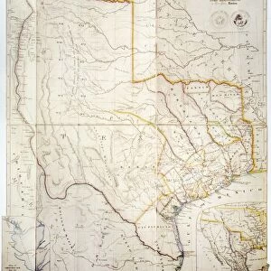
Map of North America, showing the Relative Positions of Texas and Oregon with the United States (engraving)
")
![]()
Wall Art and Photo Gifts from Fine Art Finder
Map of North America, showing the Relative Positions of Texas and Oregon with the United States (engraving)
1101471 Map of North America, showing the Relative Positions of Texas and Oregon with the United States (engraving) by English School, (19th century); Private Collection; (add.info.: Map of North America, showing the Relative Positions of Texas and Oregon with the United States. Illustration for The Illustrated London News, 11 October 1845.); Look and Learn / Illustrated Papers Collection; English, out of copyright
Media ID 23509508
© Look and Learn / Illustrated Papers Collection / Bridgeman Images
Oregon Relative Positions Showing Texas
FEATURES IN THESE COLLECTIONS
> Fine Art Finder
> Artists
> English School
> Fine Art Finder
> Temp Classification
> Maps and Charts
> Related Images
> North America
> Related Images
EDITORS COMMENTS
This engraving from the 19th century showcases a detailed "Map of North America, showing the Relative Positions of Texas and Oregon with the United States". The intricate lines and precise details transport us back in time to an era when cartography was both an art form and a means of exploration. The map highlights the relative positions of Texas and Oregon within the larger context of North America. It offers a visual representation of how these regions fit into the vast expanse of land that is now known as the United States. This historical document provides valuable insight into how borders were perceived and understood during this period. Originally created for The Illustrated London News in October 1845, this engraving holds immense historical significance. It serves as a reminder that maps have always played a crucial role in shaping our understanding of geography, politics, and identity. As we gaze upon this print today, we are reminded not only of its artistic beauty but also its educational value. It allows us to reflect on how far we have come in terms of geographical knowledge while appreciating the craftsmanship required to create such intricate maps by hand. Displayed here as part of Bridgeman Images' Fine Art Finder collection, this map invites us to explore history through cartographic lenses – reminding us that even centuries-old engravings can still captivate our imagination with their timeless appeal.
MADE IN THE USA
Safe Shipping with 30 Day Money Back Guarantee
FREE PERSONALISATION*
We are proud to offer a range of customisation features including Personalised Captions, Color Filters and Picture Zoom Tools
SECURE PAYMENTS
We happily accept a wide range of payment options so you can pay for the things you need in the way that is most convenient for you
* Options may vary by product and licensing agreement. Zoomed Pictures can be adjusted in the Cart.