Home > Europe > Russia > Maps
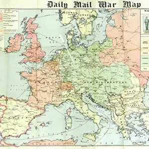
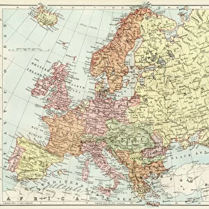
A 1930s Map Of Russia In Europe And The New Baltic States

![]()
Wall Art and Photo Gifts from Design Pics
A 1930s Map Of Russia In Europe And The New Baltic States
Design Pics offers Distinctively Different Imagery representing over 1,500 contributors
Media ID 18176906
© Hilary Jane Morgan / Design Pics
1930s 20th Countries Geographical Geography Nineteen Russia State States Thirties Twentieth Baltic
FEATURES IN THESE COLLECTIONS
> Design Pics
> Design Pics Art
> Art llustrations and Engravings
> Europe
> Russia
> Related Images
> Maps and Charts
> Early Maps
> Maps and Charts
> Related Images
EDITORS COMMENTS
This print takes us back in time to the 1930s, offering a glimpse into the intricate geography of Russia in Europe and the newly formed Baltic States. The map, skillfully illustrated by Hilary Jane Morgan, showcases the rich historical tapestry of this region during that era. As we delve into this piece, our eyes are immediately drawn to the detailed borders and boundaries that define each country. The map highlights not only Russia's vast expanse but also its close proximity to neighboring European nations. It serves as a visual reminder of how interconnected these countries were even amidst political changes and shifting alliances. The inclusion of the Baltic States adds another layer of significance to this artwork. These newly established states - Estonia, Latvia, and Lithuania - emerged from the aftermath of World War I and gained independence during a period marked by geopolitical transformations across Europe. Morgan's meticulous attention to detail allows us to appreciate both the artistic beauty and historical value embedded within this print. Each stroke on paper tells a story about an era long gone yet still resonating with echoes from our present-day world. Whether you're an avid history enthusiast or simply intrigued by cartography, this 1930s map offers an engaging window into a pivotal moment in European history. Let it transport you back in time as you explore the geographical intricacies that shaped Russia and its neighboring Baltic States nearly a century ago.
MADE IN THE USA
Safe Shipping with 30 Day Money Back Guarantee
FREE PERSONALISATION*
We are proud to offer a range of customisation features including Personalised Captions, Color Filters and Picture Zoom Tools
SECURE PAYMENTS
We happily accept a wide range of payment options so you can pay for the things you need in the way that is most convenient for you
* Options may vary by product and licensing agreement. Zoomed Pictures can be adjusted in the Cart.